
From the little-known Newberry National Volcanic Monument to the Big Obsidian Flow, central Oregon’s volcanic past erupts a visitor’s sense of historic and scientific wonder.
By Anna Lee Braunstein
Photos By Jerry Braunstein
July 2021
The predominant natural color in central Oregon is black — shiny, dark black. Sure, some greens and browns can be found, but black is everywhere, in the form of hardened lava. Lava flowed over the land from prehistoric times to as recently as 1,300 years ago and created strikingly beautiful scenes. From the peaks of Mount Newberry to the jagged cliffs of Crack in the Ground, multiple roads and paths provide visitors the chance to view and even wander through this vast and spectacular landscape. Wonderful and unique formations abound, giving the area an otherworldly appearance — so otherworldly, in fact, that Apollo astronauts actually trained there. Apollo 15 astronaut James Irwin even took a small chip of lava and placed it on the moon.
Lava Cast Forest, in Newberry National Volcanic Monument, is a rugged landscape formed by lava flows from the Newberry Volcano.
The best place to start your own lava adventure is at the Newberry National Volcanic Monument, within the boundaries of the Deschutes National Forest south of Bend, Oregon. At 54,822 acres, this volcanic region is so big that it appears to be its own mountain range. More than 400 cinder cones — hills formed from ash and magma during the volcanic eruption — are scattered throughout the area. Newberry is considered a loner volcano, and its collapse formed a caldera, or depression, at the peak. This makes it an extraordinary setting for various explorations.
A visit to Newberry should start at the Lava Lands Visitor Center. Geological and historical exhibits, as well as several films, provide a wonderful introductory course about the land. Rangers offer talks throughout the day, and they can help you plan your adventure using the 3D topographical map. Books and additional information are available at Discover Your Forest Bookstore. The center is open from May through October.
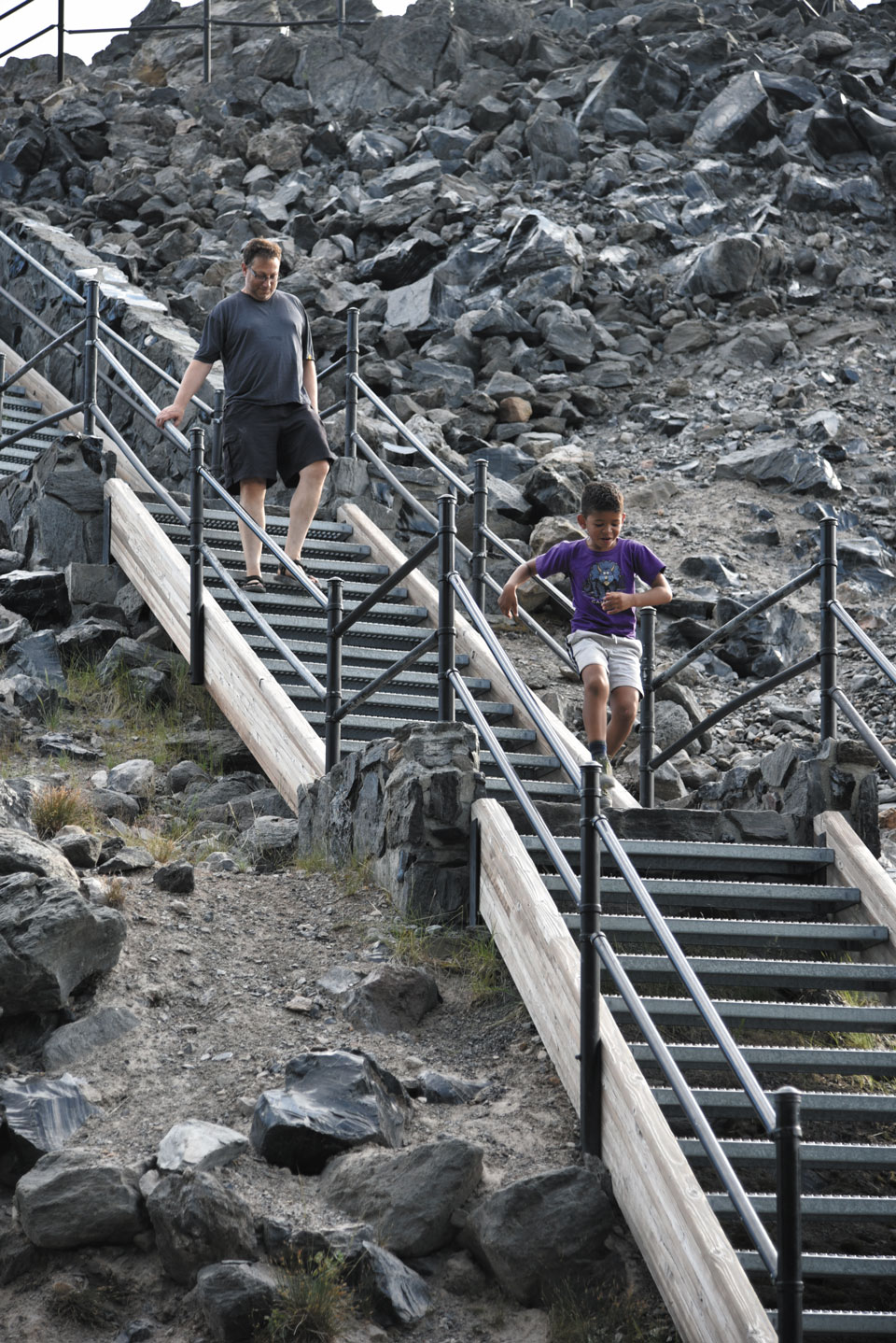
For a good visual overview of the area, pay $2 and catch the shuttle that runs every 20 minutes from the visitors center up the 1.5-mile road to the summit of the 500-foot cinder cone known as Lava Butte. A .25-mile trail circles the rim of the butte, offering panoramic vistas of the area.
Back at the visitors center, three trails provide an up-close experience with the lava. The Trail of the Whispering Pines is a 0.3-mile, flat path through high-desert plants, including lodgepole pine, greenleaf manzanita, and the leafless pinedrops. The Trail of the Molten Land is a gentle, 1.25-mile path paved atop lava that ends at the base of Lava Butte. Offshoots of the trail provide access to lava flows, lava breaches, a tree called the Lava Ness Monster, and great places to take photographs. The third path, Sun-Lava Trail, is 5.5 miles of paved trail for bicyclists and walkers going to Sunriver Resort, the Deschutes River, and Benham Falls.
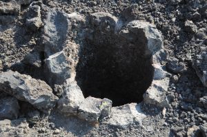
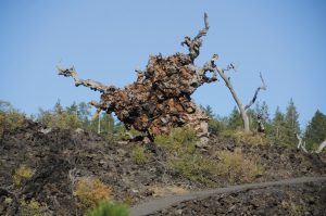
In Lava Cast Forest, caves were created from burning lava.
Just down U.S. 97 from the Lava Lands Visitor Center is Lava River Cave. Hollow channels are created as lava flows downhill, and this mile-long lava tube — the longest lava tube in Oregon — is worth exploring. Begin by descending 55 steps into the cave, which is a constant 42 degrees Fahrenheit. You might want to bring a jacket while exploring the tube, as well as a flashlight or two, and be careful on the uneven surfaces. Enter through Collapse Corridor, listen to voices in Echo Hall, admire the Sand Gardens, and take care to avoid touching these delicate formations.
Ten miles farther south stands Lava Cast Forest. An easy one-mile paved trail goes through an area where, thousands of years ago, ponderosa pine trees grew 200 feet tall. Fiery lava surrounded trees; the burned wood rotted away, leaving tree molds or lava casts. Many roots are still under the flow. Other trees twisted around, seeking to distribute water to their limbs. These trees, too, left the imprint of their convoluted bark upon the lava cast. The lava, known as a’a, a Hawaiian term, is composed of sharp, rough lava rocks called clinkers. Dead trees, ghostly white, also twist over the lava. In spring, the land is accented with the yellows, pinks, and reds of plants growing among the ancient landscapes.
A less-traveled path is the Hoffman Island Trail. It is an easy out-and-back walk into a kipuka, an island of trees surrounded by lava.
Paulina Lake and East Lake are rewarding destinations for enjoying water activities. Located at the top of Newberry Volcano, these twin crater lakes are situated within the Newberry Caldera. Paulina Lake is known for record catches of salmon and trout: a 35-pound 8-ounce brown trout was caught there in 1965. The lake is dotted with hot springs in remote locations, which require hiking, biking, or boating to access. Paulina Peak towers 2,000 feet above the lake, and at 7,984 feet is the highest point on the Newberry Volcano.
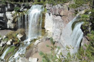
Near Paulina Lake, Paulina Falls cascades 80 feet down volcanic cliffs.
Some of the largest trout caught in the United States have been found at East Lake. In addition to fishing, both lakes are popular for boating, kayaking, swimming, paddleboarding, and water-skiing.
A side road between the two lakes goes toward Paulina Creek Falls. A short hike along Paulina Creek leads to the falls, which are actually outside the crater and drop around a small island. The view from on top includes two 80-foot waterfalls, massive boulders, and a dam at the outlet of the lake.
The Big Obsidian Flow, at 1,300 years old, is the youngest lava flow in Oregon. Its one-mile loop trail is lined with obsidian, a dark, natural glass that was formed when the lava cooled without crystalizing. The surface is sleek to the touch, but its edges are razor sharp, prompting Native Americans to use the lava for arrowheads, knives, spear points, jewelry, and ceremonial objects. They also valued it as a trading commodity.
For even more remote lava sites, take State Route 31 off U.S. 97. Along the road are such locations as Hole in the Ground, a mile-wide crater; Big Hole, an even larger crater; Crack in the Ground, a fissure two miles long and 10 to 15 feet wide, with parallel walls 70 feet high; and Lost Forest, a self-sustaining stand of ponderosa pines near a 9,000-acre stretch of sand dunes.
Continue south on State Route 31 to Fort Rock State Park. This remote spot is a “tuff” formation. The basalt magma was pushed up above the surroundings and eventually collapsed, forming the familiar volcanic crater. The volcano’s vent was in the middle of a basin, which earlier was a large, freshwater lake. Over time, strong winds and lake waves etched the side of the tuff, creating the sheer exterior walls and eventually eroding part of the tuff. As the lake dried up under the arid conditions of central Oregon, the circular tuff with a missing section took on the appearance of a military fort, thus the apt name, Fort Rock.
Climbing into the “fort” provides a close-up view of the steep walls. Sand and dirt trapped by the walls now supply soil for plants to grow, and the windblown holes in the rocks serve as nesting sites for birds and animals.
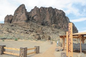
Fort Rock State Natural Area showcases a “tuff” formation caused by geologic upheaval. Towering jagged rock walls resemble a military fort.
Nighttime offers an amazing perspective of the area. Head south on State Route 20 out of Bend, Oregon, to the Pine Mountain Observatory, which is operated by the University of Oregon’s Department of Physics. The observatory is open on Friday and Saturday evenings during the summer. On clear nights, visitors can scan the vast sky through the observatory’s 24-inch telescope. Tour guides are available to answer questions and assist viewers. Go to https://pmo.uoregon.edu/visiting for directions and information about viewing as well as camping for vehicles up to 27 feet.
Traveling this land in the middle of Oregon is like taking a trip to another world. It provides an opportunity to immerse oneself in the stark beauty that only nature can create.
More Info
Newberry National Volcanic Monument Lava Lands Visitor Center
58201 S. U.S. 97, Bend, OR 97707
(541) 593-2421
https://www.fs.usda.gov/recarea/deschutes/recarea/?recid=38394
(Note: COVID-19 precautions may alter hours and availability of some of the sites described in this article.)
Central Oregon Campgrounds
Bend-Sunriver RV Campground
Bend
(877) 570-2267
www.rvonthego.com/oregon/bend-sunriver-rv-campground
East Lake Resort
La Pine
(541) 536-2230
www.eastlakeresort.com
LaPine State Park
La Pine
(800) 452-5687
https://stateparks.oregon.gov/ index.cfm?do=park.profile&parkId=32
Paulina Lake Campground
La Pine
(541) 338-5300
www.recreation.gov/camping/campgrounds/233196