
One of the Seven Natural Wonders of the World, this formation is the centerpiece of Grand Canyon National Park in Arizona and boasts distinct areas, including the wildly beautiful North Rim.
By Ann Bush, F516383
May 2023
After spending a month in Utah on my way home to Texas, the opportunity for a spur-of-the-moment side trip to the North Rim of the Grand Canyon was too tempting to ignore. I had not originally planned a stop at Grand Canyon National Park, because of a mixed experience at the park’s popular South Rim many years before. Emotions there switched between awe of a massive, enchanting gap in the ground to frustration from scores of curious tourists ignoring “do not go beyond” signs for a surreal photo. Crowd noise wiped out sounds of the wind sweeping through the canyon. For me, that encounter washed away the grand experience of this marvel of nature.
But, to my surprise, the North Rim is still the best impetuous, unplanned road trip experience in my 30-plus years of tallying miles.
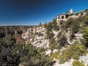
The Grand Canyon Lodge makes a good starting point for viewing the Grand Canyon from the North Rim.
As the crow flies, the North Rim is merely 10 miles from the bustling South Rim. However, it’s a four- to five-hour drive, because few bridges and roads cross the canyon. Mainly a result of the geographic location, more roads lead to the southern rim, zigzagging from major cities, and creating a busy bus tour industry and easier access for family vacationers or backpackers. Thus, since the early days, numerous visitor facilities, roads, and commercial endeavors have been built on the South Rim to create a beacon for those who want to experience nature in comfort or style.
With Utah barely in my rearview mirror, the difference between the two rims of this amazing canyon soon became evident. I was surrounded by the Kaibab National Forest on Arizona State Route 67, which aims straight for the Grand Canyon. I never left a world of pinyon-juniper, ponderosa pine, fir, and spruce mingled with golden aspen trees. Near the end of September, the colors of fall were scattered among the deep green of pines during this pleasant drive.
Expecting a row of hotels, giant gas stations, and traffic, I wondered if I had taken a wrong turn. Climbing steadily to the tallest plateau in Arizona, I found a valley full of wildflowers surrounding a lone rock-hewn country store offering one last chance to buy gas, ice, and items that campers often forget to pack. In the distance, an emerald forest beckoned, guarded by a humble Grand Canyon North Rim National Park entrance station.
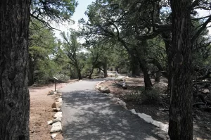
After I passed through the gate, within a mile rocky cliffs appeared and sure-footed deer watched me intently as I turned down the North Rim Scenic Drive — a beautiful, winding road leading to the lodge and information center. Short trails and scenic points along the way highlight the serene and solid landscape formed by a river, wind, and rain. (RVs over 22 feet long and vehicle-trailer combinations over 22 feet are not permitted on this scenic drive.)
After gathering maps and a bird checklist, stretching my legs was high priority, and I headed for the trail nearest the lodge. Bright Angel Point trail, a half-mile round trip, is steep in places, with occasional rock stairs, but it provides dramatic views into Roaring Springs and Bright Angel canyons. On clear days, the original foot trails used by the Paleo-Indians are visible on the canyon floor. Over 300 ancient sites or objects have been found along the Grand Canyon, among them petroglyphs, pictographs, dwelling ruins, cliff caves, pottery, hunting tools, and personal effigies dating as far back as A.D. 500.
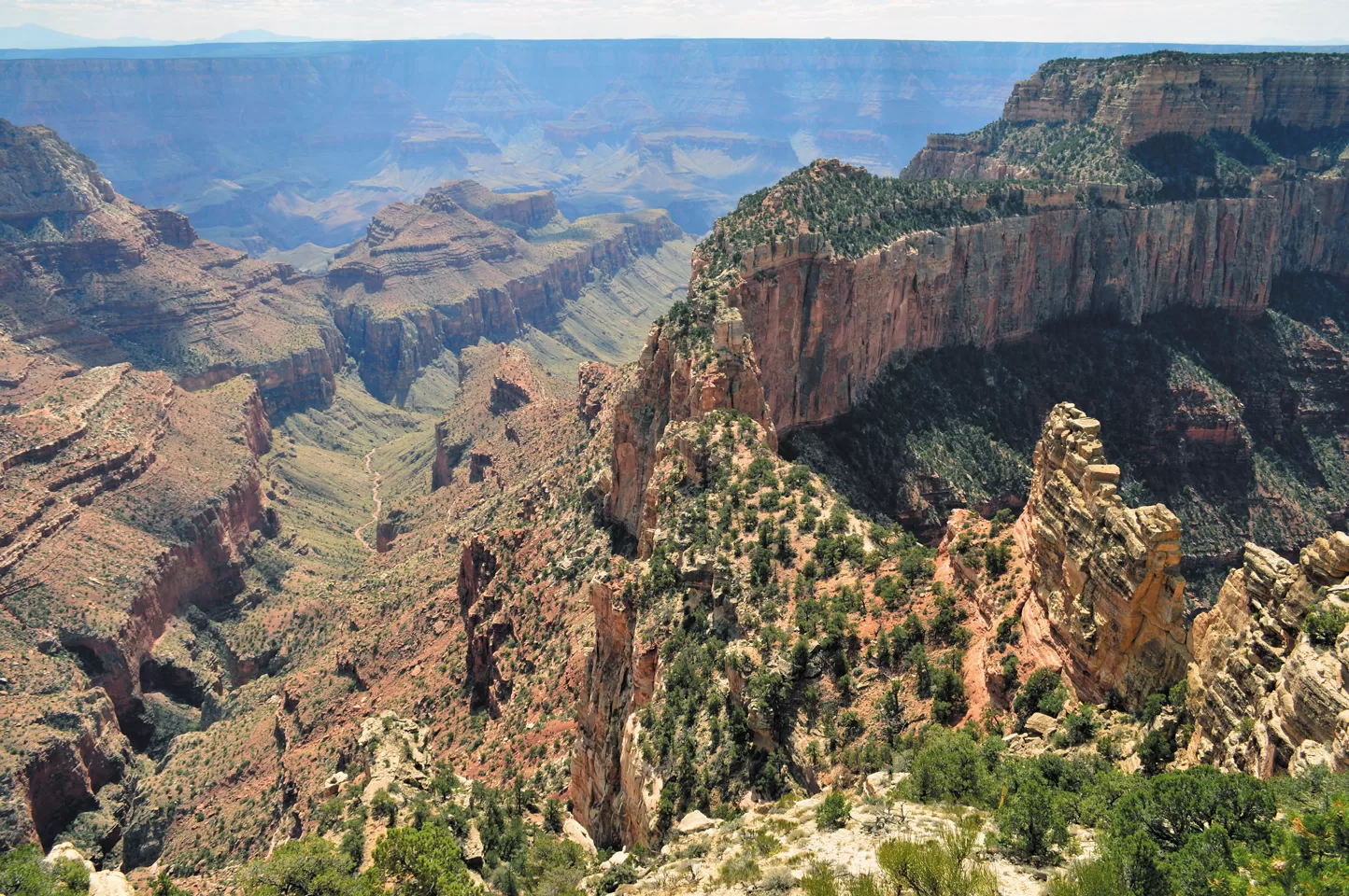
The geographic difference between the two rims is dramatic. The South Rim is basically one long wall of rock with trails leading almost straight down from an edge that overhangs the canyon. The North Rim is twice as far from the Colorado River as the South Rim, resulting in less erosion from moving water and leaving canyons within the grandest of canyons below the edge. The river is barely visible, but the panoramic landscape below is well worth the trade-off.
The tops of these smaller canyons form flat meadows and plateaus that retain water from rains to allow for farming. Over 100 ancient farming sites used by the Ancestral Puebloans are scattered in the Walhalla Plateau. Historic foot trails leading up and down to the river suggest they farmed at different elevations, following the seasons and weather conditions. They mysteriously abandoned the canyon around A.D. 1150.
A paved walking trail branches off Cape Royal Road and travels to 8,803-foot-high Point Imperial.
The North Rim is cooler, greener, and higher, creating a diverse habitat that supports a variety of plants and trees, which change as the elevation lowers to eventually reach the river bottom. Now protected by the National Park Service and left to nature, these paths continue to lead toward food and shelter for mountain wildlife species such as bobcats, mule deer, wild turkeys, the fluffy black-and-white Kaibab squirrel, and numerous canyon birds.
Following my shiny new map, I drove along Cape Royal Road to Point Imperial, the highest lookout point on the North Rim, at 8,803 feet. With dramatic views of the Painted Desert sprawling along the eastern end of the Grand Canyon, I learned these canyons were created millions of years ago. Layers of various shades of white, red, and black Precambrian rocks transform as the walls of narrow Marble Canyon seem to sway into a moving cascade of earth-toned stripes. A park ranger said that her favorite time to see the canyon is when it rains, because the wet canyon walls transform into novel-tinted hues.
Back on Cape Royal Road, I drove slowly to catch the amazing panorama up, down, and across canyon vistas. On my right was the Walhalla Plateau with nice, interpretive foot trails explaining the vegetation, describing the importance of pinyon pines and their nuts to animals and the Native Americans. The Vista Encantada area has pleasing views and sturdy picnic tables overlooking the gorge.
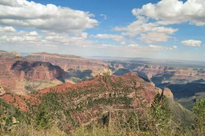
Point Imperial offers stunning views of the Grand Canyon’s hidden valleys and distant Painted Desert.
Along the way, numerous places invite visitors to stop and just soak in nature’s beauty at viewing platforms that are almost level with mountains in the far distance. And when I thought it couldn’t get any better, I stopped in my tracks at the Angel Window — an open arch in a rock wall named by folklore, justifying that only wind, rain, and an angel could create such beauty. At the end of Cape Royal Road is Angel Window Point, a large viewing platform on top of the famous arch, rewarding the patient traveler with yet another amazing arena of the Grand Canyon.
Roughly one-tenth of annual Grand Canyon visitors seek the North Rim, resulting in a much more peaceful environment. Exploring the North Rim is like exploring the canyon seen by the first peoples generations ago. The canyon is visually spectacular no matter which rim you choose. However, to really feel the canyon, one must have silence and few distractions. This physical and emotional feature attracts artists, writers, and spiritual seekers from around the world. As a result, the North Rim has become a place of reflection, creativity, and soul searching. American writer Edward Abbey worked as a fire lookout for four seasons at the North Rim, writing while living in a soaring tower.
After driving or walking most of the trails that did not lead straight down, I joined a row of admirers back at the lodge on its well-designed deck made with local rock and logs. Waiting for the sun to set, people spoke in whispers as though sitting in church. The landscape changed colors and texture as clouds moved across the sky, sprinkling sunlight at a leisurely pace. Pale-white rock on a sunny afternoon turned burnt orange as the sun slid down the sky. My camera rested at my feet so I could capture the significance of the scene. As I basked in the beauty of the performance, my muscles relaxed and stress floated away. It was a pleasant reprieve.
The South Rim may be only a few miles away, but it’s worlds apart from the North Rim. I scolded myself for not planning a longer stay after learning the lodge, cabins, and campground were booked solid. I drove in the dark to my next scheduled campsite but was thrilled to not have missed such a phenomenal experience at this canyon.
More Info
Grand Canyon National Park
www.nps.gov.grca
If You Go
The North Rim is closed between October and May, because of the threat of early snowstorms. The North Rim Campground is the only camping facility within the borders of this side of Grand Canyon National Park. It originally was designed for tents, but recent renovations have created sites for small RVs, albeit without hookups. A dump site and water refill station is available near the campground.
Numerous campgrounds and RV parks are scattered outside of the park. I reviewed a few campgrounds located in the Kaibab National Forest just a short distance north of the North Rim and found them to be excellent alternatives.
Camping Near The North Rim
DeMotte Campground
https://www.fs.usda.gov/recarea/kaibab/recarea/?recid=11699
Jacob Lak Campground
www.recreation.gov/camping/campgrounds/234529
Kaibab Camper Village
www.kaibabcampervillage.com
Stay Safe At The Grand Canyon
To properly enjoy this natural wonder, it’s imperative that you do so safely. This is to protect both you and the environment.
Be sure to stay on the designated trails and do not wander off the beaten path. Pay attention to how far away you are from the rim, and be sure you and your travel companions have both feet planted firmly on the ground. Do not climb over railings or fences to get closer to the canyon edge.
Never throw anything off the edge. Doing so can injure hikers or wildlife, and it can even start landslides.
For more information about enjoying a safe stay at Grand Canyon National Park, visit www.nps.gov/grca/planyourvisit/safety.htm.